


 Городской электротранспорт
Схемы
Пхеньян
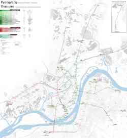 |
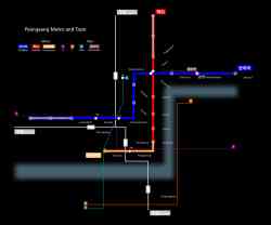
Map of trolleybus, tram and metro routes in Pyongyang, as of May 2025. Май 2025 г. |
 |
Scheme of electric transport Сентябрь 2024 г. |
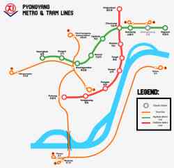 |
Схема линий метро и трамвайных маршрутов Пхеньяна. 8 февраля 2024 г. |
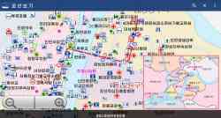 |
Alek Sigley https://tongiltours.com/north-korean-app...le-maps 20 апреля 2019 г. (примерно) |
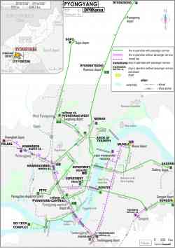 |
Схема троллейбусных линий 2018 г. |
 |
Схема трамвайных линий 2018 г. |
 |
https://en.wikipedia.org/wiki/Pyongyang_...ram.svg 15 ноября 2017 г. |
 |
Схема метро 2012 г. |
 |
Линия 1 — станция Пухын (Освоение Родины) Станция метро "Пухын" [Puhŭng Station] 10 сентября 2011 г. |
 |
Музей метрополитена [Metro museum] 23 сентября 2008 г. |
 |
Станция метро "Кэсон" [Kaesŏn Station] Май 2006 г. |
 |
This map is quite poor in resolution, but reveals valuable plans about the original network. 1991 г. |
 |
Исторические фотографии — Троллейбус (1962-1991) Туристическая схема Пхеньяна с маршрутами городского пассажирского транспорта. Май 1989 г. |
 |
Исторические фотографии — Электрический трамвай (1923-1950) Pyongyang tramway lines as of 1946 (3,19 MB) 1946 г. |
 |
Исторические фотографии — Электрический трамвай (1923-1950) Yet another map of the legacy tram. Original source unknown. 1940 г. или ранее |
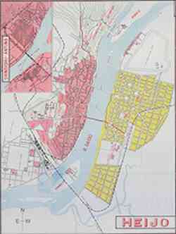 |
Исторические фотографии — Электрический трамвай (1923-1950) Карта Пхеньяна периода Японской администрации. Декабрь 1935 г. (примерно) |
Тёмная тема
Использование фотографий и иных материалов, опубликованных на сайте, допускается только с разрешения их авторов.