Transphoto

Photos are published as is and do not have purpose to promote any political and/or ideological position.

All materials are provided by users and do not reflect the opinion of the site administration team.

Close
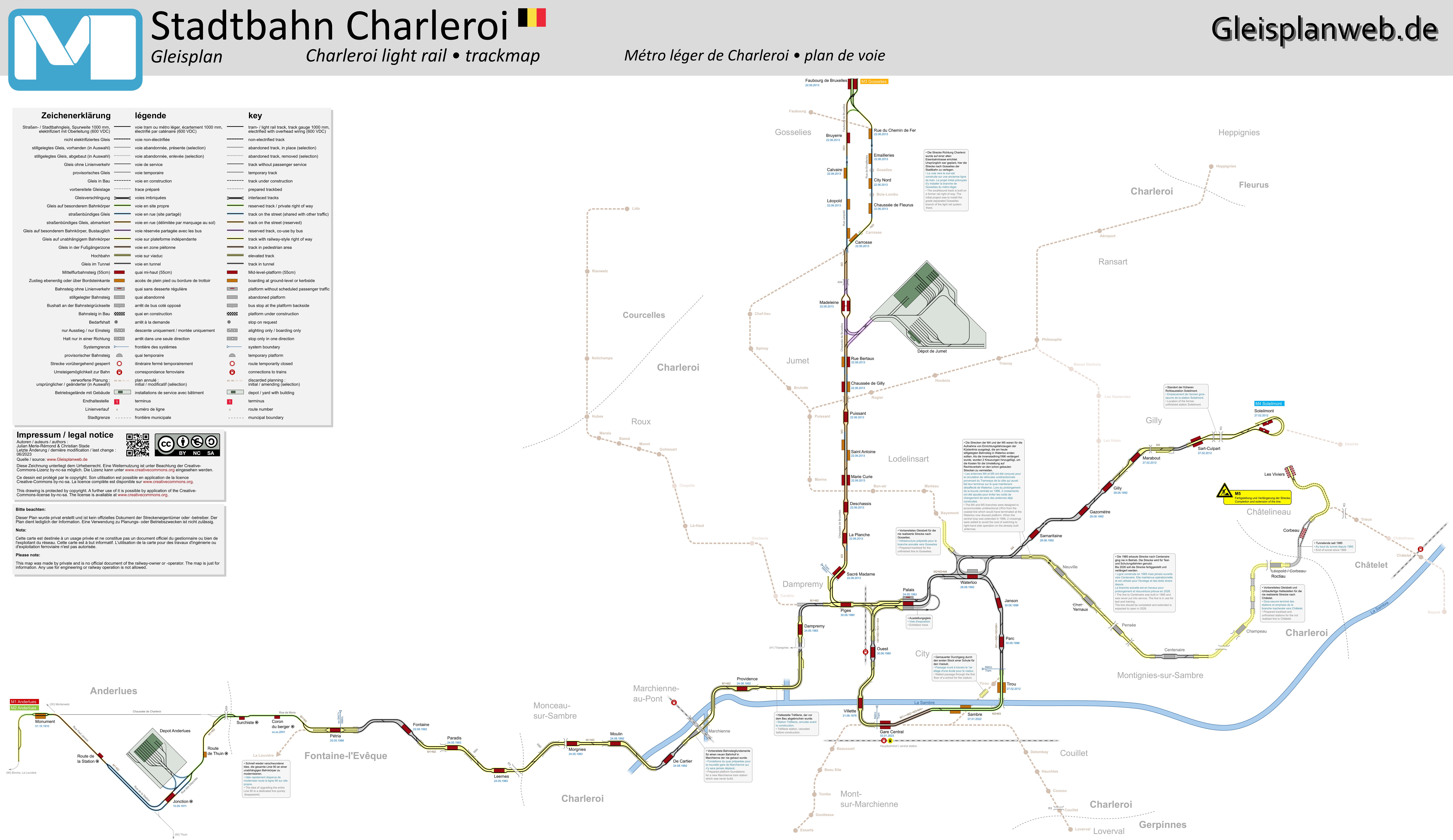
Charleroi — Maps
  CharleroiMaps
Source: www.gleisplanweb.eu
License: CC BY-NC-SA 4.0 DEED

Posted by Ymtram · East Haven - Branford           Date: Lipanj 2023 god.

Statistics

Published 12.04.2024 02:22 MSK
Pregledi — 286

Detailed info

Voting

Comments · 3

13.04.2024 00:01 MSK
Link
focus1965 · Antwerpen
Photos: 8812 · Zamjenik administratora / Interface Translation (EN/FR)
Excellent map.
Only the explanation about changing from right to left hand traffic beyond Waterloo is highly dubious. Actually, I had never read anywhere (not even in official documents) that it was ever intended to transfer trams from the coast to Charleroi. Furthermore, it could be possible to broken out the junction and simply driven on the right, as on all other routes: middle platforms are used almost everywhere on this system.
These branches should have come into service as early as 1985, but the then remaining tram operator (SNCV/NMVB) could not reach an agreement with the other operator (STIC), which had the monopoly on public transport operation (but only with buses) in this particular area.
During the planning, the STIC was effectively involved and demanded that boarding would be done on the right, analogous to what happens with buses. Their travellers were so familiar with this and there was no reason for them (the STIC) to change it...
In 1991, both companies merged but it's clear for everyone that it would take many years before everyone could share the same offices...
The STIC's specific desire didn't disappear in a one-year span and so for the sake of peace, left-hand traffic was inaugurated in 1992, as it had been planned long before...
0
+0 / –0
20.05.2025 12:04 MSK
Link
mpelov · Sofia
Photos: 95
Is there a plan to bring the light metro to the airport? The M3 line passes not too far from it.
+2
+2 / –0
20.05.2025 22:18 MSK
Link
focus1965 · Antwerpen
Photos: 8812 · Zamjenik administratora / Interface Translation (EN/FR)
No. The reason is complicated but more easy to understand with an explanation. Route M3 is BTW an ordinary tram route, running (also) in a very small village. But this is not the real reason.
In Belgium, the local transport is financed by the regions (Flanders, Wallonia and Brussels); in this case Wallonia.
The railways are financed by the Belgium (national) authorities. Wallonia asked since long a railway connection to the local airport of Charleroi. Sometimes (red line...) it's half accepted (for later...) but now it's refused (red line again) and Wallonia then introduced an additional new bus line from Luttre station (on the railway line from Brussels). There was already a dedicated line from Charleroi. Purely informative: a special (and very expensive) fare applies to both lines. The airport itself is also not an asking party: they have an exclusive contract with a private bus service from Brussels: also very expensive and the airport gets a high commission on each ticket sold.
The few times I drive to Charleroi airport by car, I automatically pass the Jumet depot: you can just see it from the highway exit. It's a very short distance, but there is no interest in it.
+3
+3 / –0

Your comment

Please do not discuss political topics or you will be banned for at least one month!
You need to log in to write comments.