


 Mestská Elektrická Hromadná Doprava
Maps (지도)
Seoul
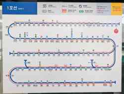 |
Metropolitain — Incheon — Line 1 (인천 — 1호선) Схема первой линии сеульского метрополитена 21. novembra 2025 |
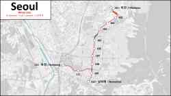 |
• Схема маршрута линии «Wirye», будущие остановки в настоящее время не имеют окончательного названия. 30. júla 2025 |
 |
A map of the Wolmi Sea Train posted at the station. 30. apríla 2023 |
 |
A map of the Wolmi Sea Train line. 2019 |
 |
Incheon Airport people mover (인천공항 피플 무버) Incheon International Airport December 2017 (približne) |
 |
Metropolitain — Seoul — Line 5 (서울 — 5호선) Chungjeongno Station 19. augusta 2014 |
 |
Metropolitain — Uijeongbu — VAL U-Line (의정부 경전철) A map of the Uijeongbu Line (U-Line) VAL automated line. 2012 |
 |
A map of the Yongin EverLine automated line. 2009 |
 |
7. decembra 2008 |
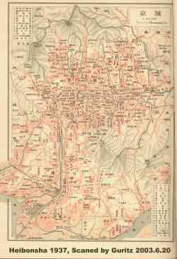 |
Historical photos (오래된 사진) — Tramway Heibonsha — 1937 Map of Keijo (now Seoul) 1937 |
 |
Historical photos (오래된 사진) — Tramway Expired copyright Zaslal Gamerdgl |
Dark Theme
Použitie fotografií a iných materiálov zverejnených na týchto stránkach je povolené len so súhlasom ich autorov.