


 Električni gradski prijevoz
Maps and Plans
Boston
 |
Travanj 2013 god. |
 |
Схема первой подземки США с датами открытия. Public Domain. Источник: http://en.wikipedia.org/wiki/File:Tremont_Street_Subway.jpg 2005 god. |
 |
1965 god. |
 |
Eastern Massachusetts 1913 god. |
 |
Plan of Causeway Street Station adjacent to the North Union Station 1913 god. |
 |
Plan of track layout at Sullivan Square Station 1913 god. |
 |
Map of the Boston Elevated Railway Co. system 1908 god. |
 |
New Sullivan Square elevated storage yard of the Boston Elevated Railway Studeni 1907 god. |
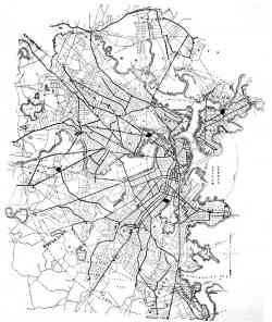 |
Map of the Boston, showing lines of the West End Street Railway Co. 1895 god. |
Tamna tema
Zabranjena je uporaba slika s ove stranice bez dopuštenja autora.