


 Mestská Elektrická Hromadná Doprava
Maps
Coast Tram
 |
Source: www.gleisplanweb.eu August 2023 |
 |
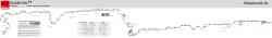
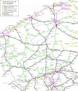
Схема маршрута из официального буклета. 2 закрытые в данный момент остановки в схеме отсутствуют. В схеме отмечен транспорт, на который можно пересесть на указанных остановках. 25. septembra 2011 |
 |
Береговой трамвай — самый длинный трамвайный маршрут в мире. 68 километров. 19. novembra 2010 |
 |
Береговой трамвай — самый длинный трамвайный маршрут в мире. 68 километров. 18. novembra 2010 |
 |
Береговой трамвай — самый длинный трамвайный маршрут в мире. 68 километров. 17. novembra 2010 |
 |
Береговой трамвай — самый длинный трамвайный маршрут в мире. 68 километров. 15. novembra 2010 |
 |
Image used under 'Fair Use' conditions. 2007 |
 |
Coast Tram 1991 |
Dark Theme
Použitie fotografií a iných materiálov zverejnených na týchto stránkach je povolené len so súhlasom ich autorov.