


 Transporte eléctrico urbano
Maps
Tranvía costero
 |
Source: www.gleisplanweb.eu Agosto 2023 a. |
 |
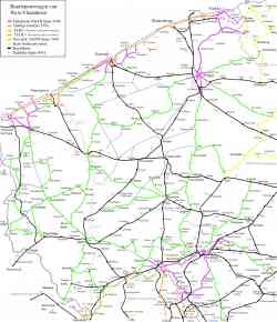
Схема маршрута из официального буклета. 2 закрытые в данный момент остановки в схеме отсутствуют. В схеме отмечен транспорт, на который можно пересесть на указанных остановках. 25 de septiembre del a. 2011 a. |
 |
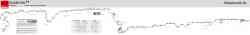
Береговой трамвай — самый длинный трамвайный маршрут в мире. 68 километров. 19 de noviembre del a. 2010 a. |
 |
Береговой трамвай — самый длинный трамвайный маршрут в мире. 68 километров. 18 de noviembre del a. 2010 a. |
 |
Береговой трамвай — самый длинный трамвайный маршрут в мире. 68 километров. 17 de noviembre del a. 2010 a. |
 |
Береговой трамвай — самый длинный трамвайный маршрут в мире. 68 километров. 15 de noviembre del a. 2010 a. |
 |
Image used under 'Fair Use' conditions. 2007 a. |
 |
Tranvía costero 1991 a. |
Tema oscuro
El uso de fotos y otros materiales publicados en el sitio web solo está permitido bajo la autorización de sus autores.