


 Городской электротранспорт
Схемы
Береговой трамвай
 |
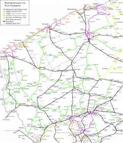
Source: www.gleisplanweb.eu Август 2023 г. |
 |
Схема маршрута из официального буклета. 2 закрытые в данный момент остановки в схеме отсутствуют. В схеме отмечен транспорт, на который можно пересесть на указанных остановках. 25 сентября 2011 г. |
 |
Береговой трамвай — самый длинный трамвайный маршрут в мире. 68 километров. 19 ноября 2010 г. |
 |
Береговой трамвай — самый длинный трамвайный маршрут в мире. 68 километров. 18 ноября 2010 г. |
 |
Береговой трамвай — самый длинный трамвайный маршрут в мире. 68 километров. 17 ноября 2010 г. |
 |
Береговой трамвай — самый длинный трамвайный маршрут в мире. 68 километров. 15 ноября 2010 г. |
 |
Image used under 'Fair Use' conditions. 2007 г. |
 |
Береговой трамвай 1991 г. |
Тёмная тема
Использование фотографий и иных материалов, опубликованных на сайте, допускается только с разрешения их авторов.